Africa
Visit Serengeti
Visit Victoria Falls
Visit Hwange National Park
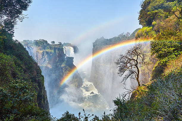
Victoria Falls
Mosioa tunya
The smoke that Thunders in Victoria Falls
Victoria Falls is classified as the largest based on its combined width of 1,708 metres and height of 108 metres
resulting in the world's largest sheet of falling water.For a considerable
. . .
distance upstream from the falls, the Zambezi flows over a level
sheet of basalt in a shallow valley, bounded by low and distant sandstone hills.The river's course is dotted with numerous tree-covered
islands, which increase in number where the river approaches the falls.There is a flat plateau extending in all directions The falls are
formed where the full width of the river plummets in a single vertical drop into a transverse chasm 1,708 metres wide, carved along a fracture zone in the basalt plateau.
The depth of the chasm, called the First Gorge, varies from 80 metres at its western end to 108 metres in the centre.
The only outlet from the First Gorge is a 110-metre-wide gap about two-thirds of the way across the width of the falls
from the western end. The whole volume of the river pours into the Victoria Falls gorges from this narrow cleft.There are two islands
on the crest of the falls: Boaruka Island (or Cataract Island) near the western bank, and Livingstone Island near the middle.
At less than full flood, additional islets divide the curtain of water into separate parallel streams.The main streams are named,
in order from Zimbabwe (west) to Zambia (east) the Devil's Cataract (called Leaping Water by some), the Main Falls, the Rainbow Falls
(the highest) and the Eastern Cataract.Victoria Falls seen from Zimbabwe in August, 2019.The River Zambezi, upstream from the falls,
experiences a rainy season from late November to early April, and a dry season the rest of the year. The river's annual flood season
is February to May with a peak in April. The spray from the falls typically rises to a height of over 400 metres , sometimes up to
twice as high, and is visible from up to 50 km away. At full moon, a 'moonbow' can also be seen. During the flood season, however,
the foot and the face of the waterfall can't be seen. When the dry season takes effect, the islets on the crest become wider and more numerous.
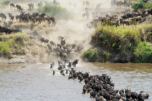
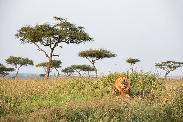
Serengeti
Wildlife
Home to every creature
Serengeti National Park is a World Heritage Site teeming with wildlife: over 2 million ungulates,
4000 lions, 1000 leopard, 550 cheetahs and some 500 bird species inhabit an area close to 15,000 square
. . .
kilometers in size. Join us on a safari and explore the endless Serengeti
plains dotted with trees and kopjes from which majestic lions control their kingdom; gaze upon the Great
Migration in awe or find an elusive leopard in a riverine forest. Or perhaps see everything from a bird’s-eye
view and soar over the plains at sunrise during a hot air balloon safari. Accommodation options come in every price
range – the sound of lions roaring at night is complimentary.
Hwange
Hwange National Park
WildLife in Hwange
Hwange National Park is the largest in Zimbabwe, covering an impressive 14,650 sq km, with
the main entrance located a two-hour drive or 30-minute flight south of Victoria Falls. The park is named after a local
. . .
Nhanzwa chief, and was once the royal hunting ground for the Ndebele warrior-king Mzilikazi, before being
classified as a protected National Park in 1929. As you’d expect from a park of this size, the breadth of
wildlife species is astounding. Over 100 species of mammals reside here, whilst almost 400 species of birds
decorate the skies. Perhaps most exciting is the 40,000-strong population of tusker elephants, whose presence
is world-renowned and a joy to watch day after day. The dry season (from July to October) is the best time to
visit Hwange, as large concentrations of wildlife– particularly the wonderful elephant herds – descend upon
the area to drink from the waterholes in order to survive in this hot and unforgiving environment. Yet, whilst
the rains from December to March will see the wildlife dispersing across the park, thus making them harder to
spot, the summer showers also bring forth stunning vegetation. This ensures mesmeric bird-watching opportunities as
the local population finds itself bolstered by the migrants coming down from the Northern Hemisphere. Hwange National
Park truly is a year-round wonderland.
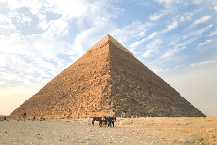
Egypt
Pyramids
Misterious Pyramids
The Giza pyramid complex (also called the Giza necropolis) in Egypt is home to the Great
Pyramid, the Pyramid of Khafre, and the Pyramid of Menkaure, along with their associated pyramid complexes and the
Great Sphinx. All were
. . .
built during the Fourth Dynasty of the Old Kingdom of ancient Egypt, between c. 2600 – c. 2500 BC.
The site also includes several temples, cemeteriesThe three main pyramids at Giza, together with subsidiary pyramids
and the remains of other structures The site is at the edge of the Western Desert, approximately 9 km (5.6 mi) west
of the Nile River in the city of Giza, and about 13 km (8.1 mi) southwest of the city centre of Cairo. It forms the
northernmost part of the 16,000 ha (160 km2; 62 sq mi) Pyramid Fields of the Memphis and its Necropolis UNESCO World
Heritage Site, inscribed in 1979.[1] The pyramid fields include the Abusir, Saqqara, and Dahshur pyramid complexes,
which were all built in the vicinity of Egypt’s ancient capital of Memphis.The Great Pyramid and the Pyramid of Khafre are
the largest pyramids built in ancient Egypt, and they have historically been common as emblems of Ancient Egypt in the Western
imagination.[2] They were popularised in Hellenistic times, when the Great Pyramid was listed by Antipater of Sidon as one of
the Seven Wonders of the World. It is by far the oldest of the Ancient Wonders and the only one still in existence.",
chinhoy:"Chinhoyi Cave is technically a circular sink hole in the surrounding dolomite resulting in a funnel-shaped cavity in the
limestone, produced by the action of water on the soluble crystalline rock. Collapses of other tunnels and caverns can be seen
from the sink holes and depressions within the surrounding area. The deposits of dolomite appear to have been laid down many
millions of years ago in a shallow sea. Traces of algae found as fossils within the dolomites are amongst the earliest forms of
life in Zimbabwe called stromatolites. Dolomite is particularly absorbent and rain water vanishes into the rock, as it percolates
downwards, it absorbs carbon-dioxide from the respiration of plant roots and the bacterial decay of humus and the slightly acidic
solution dissolves the calcium carbonate in the dolomite so forming the characteristic underground caverns.Chinhoyi Caves are made
up of the sunlit Sleeping Pool and the artificially lit Dark Cave.The Sleeping Pool is accessible by two routes:Through the main
entrance by way of a long dark inclined passage, where the view of the water has been compared to the famous Blue Grotto of Capri.
Light enters the passage from either end, and two small shafts in the roof ventilate and illumine the sloping passageway. On one side
of the passage is a large chamber which has been occupied at different times in the history of the cave. For generations in the past,
wild animals have descended this passage to drink at the pool, and the blocks of limestone are polished smooth by the constant rubbing
past of thirsty animals. The floor was rough and uneven, but has been tidied up in recent years.
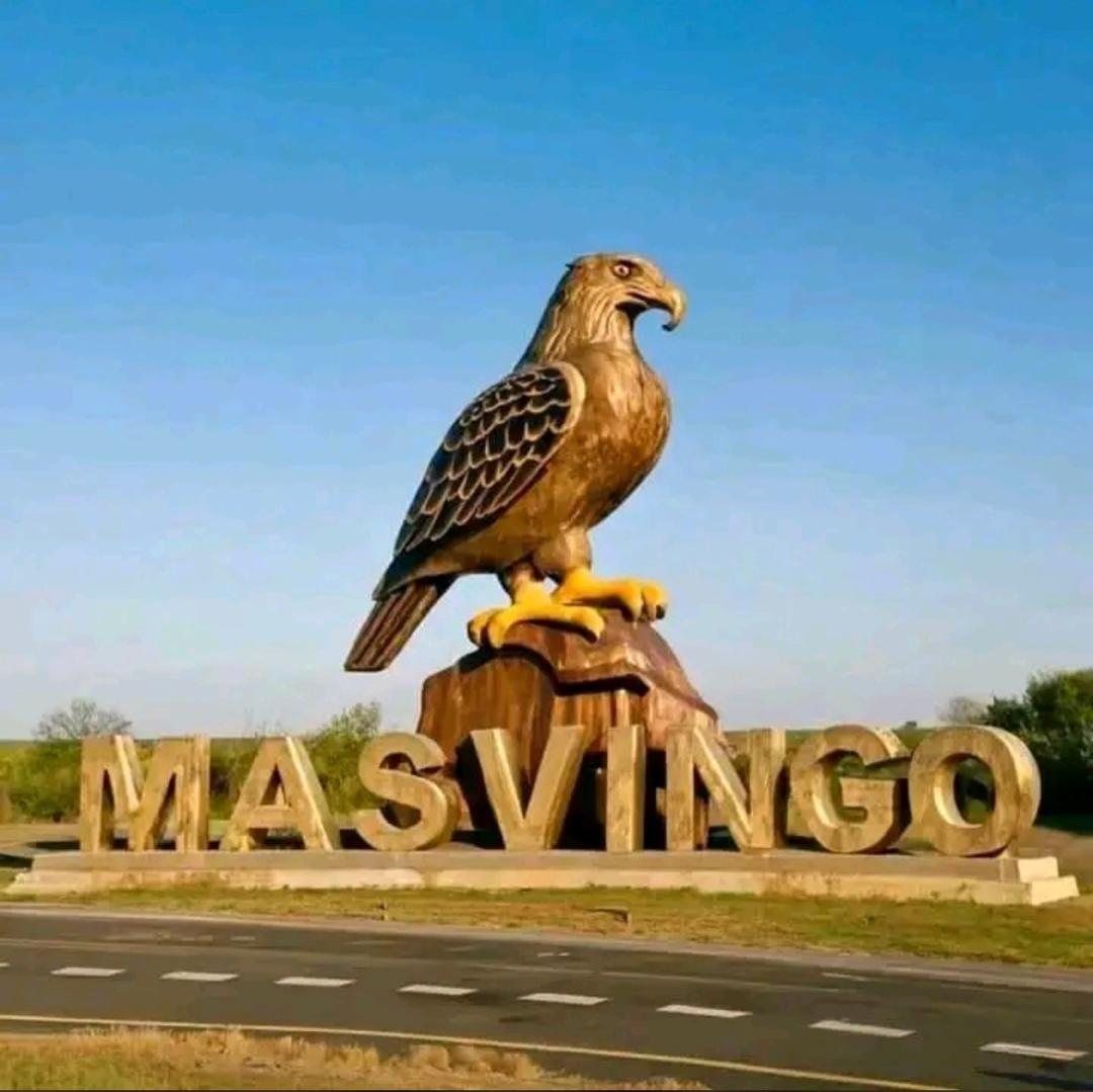
Great Zimbabwe
Masvingo
Great Zimbabwe in Masvingo
Great Zimbabwe is the name of the stone ruins of an ancient city near modern day Masvingo, Zimbabwe. People lived in Great
Zimbabwe beginning around 1100 C.E. but abandoned it in the 15th century. The city was the capital of
. . .
the Kingdom of Zimbabwe, which was a Shona (Bantu) trading empire. Zimbabwe means 'stone houses' in Shona.Great Zimbabwe was part
of a large and wealthy global trading network.Archaeologist
have found pottery from China and Persia, as well as Arab coins in the ruins there. The elite of the Zimbabwe Empire
controlled trade up and down the east African coast. However, the city was largely abandoned by the 15th century as the Shona people migrated elsewhere.
The exact reasons for the abandonment are unknown, but it is likely that exhaustion of resources
and overpopulation were contributing factors.The archaeological site at Great Zimbabwe consists of several sections. The first section is theHill Complex,
a series of structural ruins that sit atop the steepest hill of the site. This is generally believed to have been the religious center of the site.
The Hill Complex is the oldest part of Great Zimbabwe, and shows signs of construction that date to around 900 C.E.The ruins
of the second section, the Great Enclosure, are perhaps the most exciting. The Great Enclosure is a walled, circular area below the Hill Complex
dating to the 14th century. The walls are over 9.7 meters high in places, and the enclosure’s circumference is 250 meters.The walls were built
without mortar, relying on carefully shaped rocks to hold the wall’s shape on their own.Inside the enclosure is a second set of walls,
following the same curve as the outside walls, which end in a stone tower 10 meters high.While the function of this enclosure is unknown,
archeologists suggest it could have been a royal residence or a symbolic grain storage facility. It is one of the largest existing structures
from ancient sub-Saharan Africa.The Valley Ruins consist of a significant number of houses made mostly of mud-brick near the Great Enclosure.
The distribution and number of houses suggests that Great Zimbabwe boasted a large population, between 10,000–20,000 people.Archaeological
research has unearthed several soapstone bird sculptures in the ruins. These birds are thought to have served a religious function, and may have been
displayed on pedestals. These birds appear on the modern Zimbabwean.
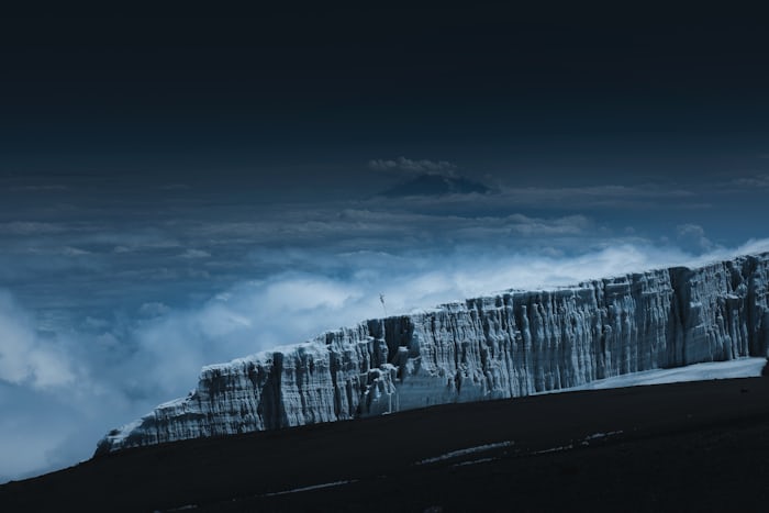
Kilimanjaro
Mount Kilimanjaro
World's Tallest Mountain
Mount Kilimanjaro, located in Tanzania, East Africa, is the highest mountain in Africa with an elevation of 19,341 feet (5,895 meters). It is the largest free-standing mountain in the world and is one of the . . . seven summits.Its snow-capped peak towers above the surrounding Savannah’s and is part of the Kilimanjaro National Park, which is home to a variety of unique flora and fauna. While it is a dormant volcano, it still serves as an important source of inspiration for climbers and outdoor enthusiasts from around the world.
Kariba
Kariba Dam
World's biggest man made Lake in Kariba
Kariba Dam, concrete arch dam across the Zambezi River at Kariba Gorge, on the border between Zambia and Zimbabwe.
Construction of the dam began on Nov. 6, 1956, and was completed in 1959. The structure
. . .
is 128 metres (420 feet) high with a crest 579 metres (1,899 feet) in length and a volume of 1,032,000 cubic metres (1,350,000 cubic yards).
The dam creates Lake Kariba, and it supplies some 6,700,000,000 kilowatt-hours of electricity annually, generated
by Kariba North Bank and South Bank companies (Zambia and Zimbabwe, respectively). Its creation required the resettlement
of more than 30,000 Batonka tribespeople of Zambia and the evacuation of thousands of wild animals (“Operation Noah”).
Some Africans initially opposed construction of the dam, seeing it as a symbol of the unpopular Federation of Rhodesia
and Nyasaland, which dissolved into Rhodesia (now Zimbabwe) and Zambia in 1963. Later, however, the dam was accepted
because of the inexpensive electric power it furnishes to Zambia’s prosperous copper industry.
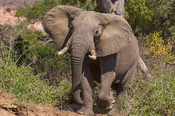
Gonarezhou
Gonarezhou National
Wildlife in Chiredzi
Gonarezhou National Park, as the area is known today, has an incredibly rich and turbulent history from
early human settlements by the Shangaan (Tsonga) people, to the ivory trade, later becoming
. . .
a game reserve in 1935 before being proclaimed a National Park in 1975. Gonarezhou is in the remote southeast
corner of Zimbabwe on the border with Mozambique, with which it shares a 100 km
boundary. The park forms an integral part of one of the largest conservation areas in the world- the Greater Limpopo
Transfrointier Park (GLTP), established in 2002. GLTP joins some of the iconic national parks of Zimbabwe, Mozambique, and South Africa.
The Park, known as “the place of elephants”, is home to over 11,500 of these gentle giants, one of the highest densities of pachyderms in any
protected area in Africa. History talks of elephants taller than the trees and whilst this may be a stretch – several uniquely impressive
individuals still roam the wilderness of Gonarezhou, descendants of the famed bulls of yesteryear such as “Dhulamiti” (the one who is taller
than the trees). Apart from being “the place of elephants”, Gonarezhou is home to a rich diversity of species with several unique and range
limited species. The Park is home to over 450 species of birds, 89 large mammal species, 61 small mammals, over 50 fish species, 116 identified
reptile species and 34 amphibian species. Of these species, some 15 are classified as vulnerable, 6 endangered and 5 as critically endangered species.
Chinhoyi
Chinhoyi Caves
Wonder Caves in Chinhoyi
The Wonder Hole , is the main feature of the caves which is in fact a “swallow hole” or a large cavern with a collapsed roof.
The walls of the wonder Hole drop vertically down for 150 feet to the sleeping pool in which our adrenaline junkies normally use for
. . .
Scuba Diving.The pool is unbelievably blue and crystal clear which reflects great depth non-flowing water .
The traditional name for the Caves is “Chirorodziva” which means the “Pool of the Fallen”. The name was derived from an incident which
took place in the 1830s when the Angoni Tribe, who were moving northwards surprised people living near the Caves and flung them into the pool.

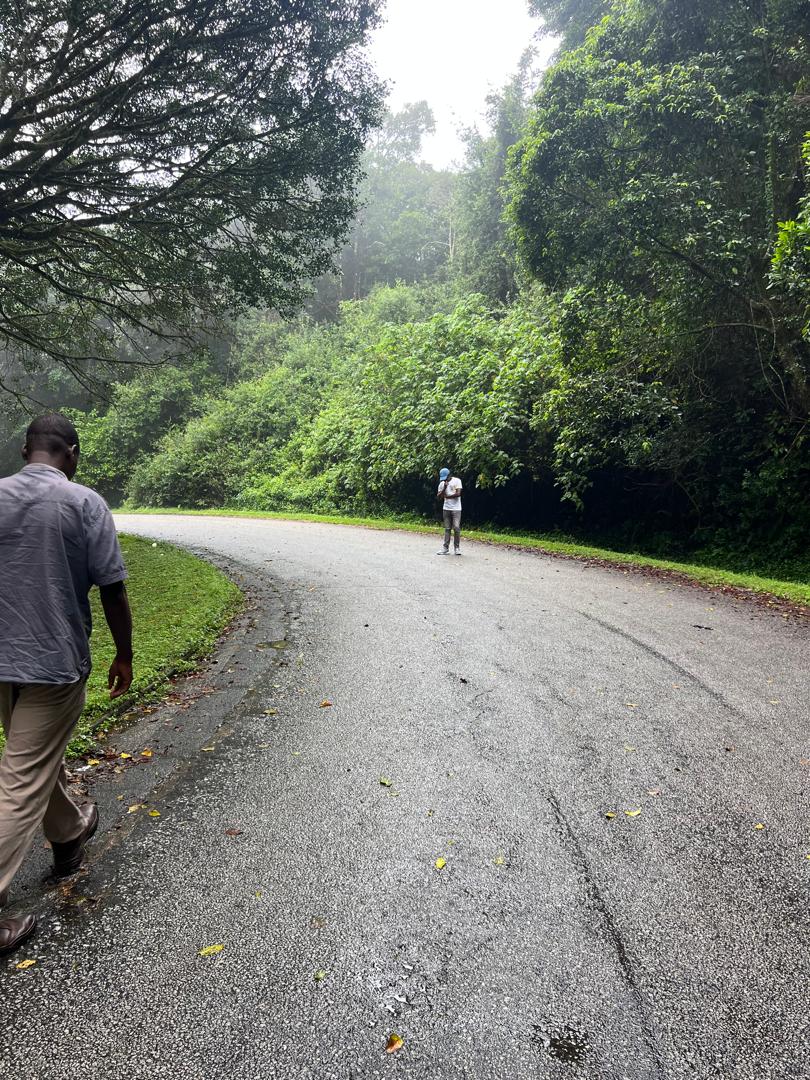
Vumba
Vumba Mountains
Forest mountains in Bvumba
The Bvumba Mountains or Vumba Mountains lie on the border between Zimbabwe and Mozambique.
They are situated some 10km south east of the city of Mutare in Zimbabwe. The highest point in the area is the Castle
. . .
Beacon which is at 1,911m above sea level and together with the Chimanimani Mountains to the south and Nyanga Mountains
to the north form part of what is often refered to as the eastern
Highlands. Bvumba is the local language (Shona) word for mist and the area is often referred to as the ‘Mountains of
Mist’ as the early mornings often start with a mist which can clear by mid-morning, or remain for days! The mountains are capped by cool
green hills in summer and golden in winter. The Botanical Gardens were one of the best in Africa, the views are still splendid. Walking
the area you will traverse different vegetation, landscapes, waterfalls and fantastic views.
The area is renown for its unique bird life and you will also frequently spot the local Samango monkeys along the roadside and in the forests
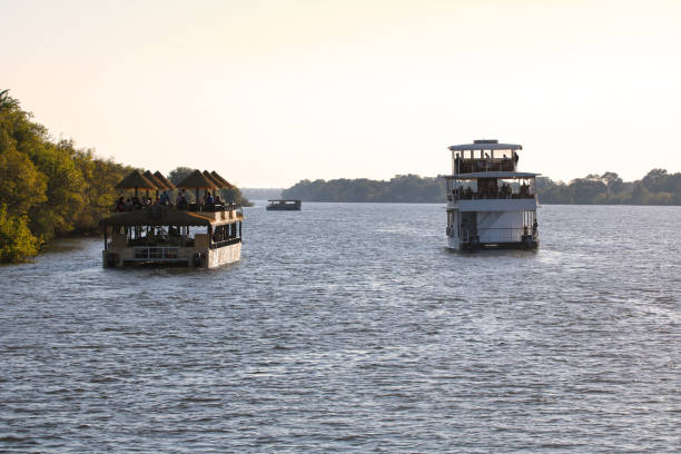
Zambezi
Zambezi River
Healing waters in Zambezi
The Zambezi is the fourth-longest river in Africa, the longest east-flowing river in Africa and the largest flowing into the Indian Ocean
from Africa.For about 500km / 310mi it serves as the border between Zambia and Zimbabwe, thundering over the Victoria Falls
. . .
and through the narrow, steadily deepening Batoka Gorge, providing a fantastic playground for white-water rafters.
Its unique value is that it is less developed than other rivers regarding human settlement and many areas along its banks have even been
granted protected status. The Lower Zambezi National Park flanks the river on the Zambian side and Mana Pools National Park on the Zimbabwean side. This whole area of the Zambezi supports one of Africa’s most important wilderness areas as it provides sustenance to a diverse array of game, birdlife and fish species.
The Zambezi also supports several hundred species of fish, some of which are endemic. Important species include cichlids that are fished
for food, as well as catfish, tigerfish, yellowfish and other large species (the bull shark is sometimes known as the Zambezi shark
after the river but it is actually found around the world).After having provided power, food and transport for many people, and a home for untold numbers of wildlife, the
river ends its journey through Mozambique and out towards the Indian Ocean.
The Zambezi’s most noted feature is Victoria Falls but there is so much more. Other notable waterfalls include the Chavuma
Falls at the border between Zambia and Angola, and Ngonye Falls, near Sioma in Western Zambia. There are two primary
sources of hydroelectric power on the river, the Kariba Dam (which provides power to Zambia and Zimbabwe) and the Cahora Bassa
Dam in Mozambique, which provides power to Mozambique and South Africa. There is also a smaller power station at Victoria Falls.
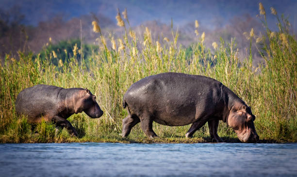
Hippo, Nile crocodiles
Nyanga
Nyanga Mountains
High Pick mountains in Nyanga
Mount Nyangani (formerly Mount Inyangani) is the highest mountain in Zimbabwe at 2,592 metres or 8,504 feet.
The mountain is located within Nyanga National Park in Nyanga District, about 110 km (68 mi) north-northeast
. . .
of Mutare. The summit lies atop a small outcrop of rock around 40 metres or 130 feet above the surrounding area. The remainder of the peak is a broad moor
of mainly rolling hills and plateau with an area of about 8 km2. The edges of this plateau then fall steeply to the east and west
sides. The mountain vegetation is largely composed of heath
around the summit plateau with evergreen forest along the wetter eastern
slopes and grassland to the western side. Annual rainfall totals are high (around 2,200 millimetres or 87 inches) but long spells of
dry weather occur during the winter period of May to August. Due to its relatively low altitude and tropical location, snowfall is very rare, l
ast recorded in August 1935
World
Nature
Wonderful Creatures
Mount Nyangani (formerly Mount Inyangani) is the highest mountain in Zimbabwe at 2,592 metres or 8,504 feet.
The mountain is located within Nyanga National Park in Nyanga District, about 110 km (68 mi) north-northeast
. . .
of Mutare. The summit lies atop a small outcrop of rock around 40 metres or 130 feet above the surrounding area. The remainder of the peak is a broad moor
of mainly rolling hills and plateau with an area of about 8 km2. The edges of this plateau then fall steeply to the east and west
sides. The mountain vegetation is largely composed of heath
around the summit plateau with evergreen forest along the wetter eastern
slopes and grassland to the western side. Annual rainfall totals are high (around 2,200 millimetres or 87 inches) but long spells of
dry weather occur during the winter period of May to August. Due to its relatively low altitude and tropical location, snowfall is very rare, l
ast recorded in August 1935